Slesse Northeast Buttress
Yesterday Nick and I climbed the northeast buttress of Slesse. A bit of a change from the usual obscure peak that I seem to climb. Originally Nick wanted to drag me up the East Pillar, but we figured that since neither of us had done this classic alpine rock route yet, we should climb that first. The NE buttress is quite big, about 800m of climbing and 25 pitches up to 5.8/5.9. The climbing isn’t all that sustained, but there’s a lot of it. I’ve wanted to climb this now ever since seeing it in the front page of Alpine Select but wasn’t sure if I was ready for it yet. I figured a few days of climbing in Squamish this summer would get me up to speed on climbing.
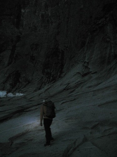
We left Vancouver rather late, since Nick spent the day in Squamish sport climbing (probably to get him warmed up for the steep headwall pitches), and we had to stop in Abbotsford for some groceries (ie. cinnamon buns, chocolate, and granola bars). The trailhead to the Slesse Memorial starts from Nesakwatch Creek FSR. It’s in 2WD condition, slighty rough in some spots. It’s amazing to think that a big route like this could be so close to the flat Fraser Valley. We started hiking in around 10:30pm, and arrived at the Memorial an hour later. The trail/roadbed here is quite pleasant, and is quite manageable by headlamps. The views of Slesse and its many steep buttress and walls from the memorial (and from the road) are quite impressive. Fortunately it was dark, so I couldn’t get intimidated by how big the route actually was.
Apparently if you don’t bivy on the route, you’ll probably bivy on the descent. We didn’t want to bivy on the route or on the descent, so we woke up at 3:45am, after having just four short hours of sleep. A short breakfast of cinnamon buns followed. I really do think cinnamon buns are the perfect alpine breakfast, there’s minimal faff involved, and you get two out of the three mountain food groups. Fat and sugar. You don’t get salt with granola or oatmeal anyways.
We hammered it up to the Propeller cairn along a pretty good trail. On Dec 9, 1956, Trans Canada Airline Flight 810 crashed somewhere around the south peak of Slesse, hence the memorial and propeller cairn. We probably passed by a fair amount of the debris, but we couldn’t see anything in the dark. Nick thought that if either of us found a skull, our new nickname could be Dr. Doom. I’m not sure if that’s the most confidence inspiring nickname for a climbing partner. It was quite tricky getting to the NE buttress in the dark. From the propeller cairn, you have to cross under both the Slesse Glacier and the Bypass glacier. I think we traversed too high at first which brought us level with the glacier or snow patches so we had to drop further down to slabs to cross it. There’s also a notch in between them to scramble up, and then scramble down a grassy/mossy gully on the other side. It was probably a good thing it was still pitch black at this point. Although most of the Bypass glacier had already slid off, there were still large chunks of the glacier on the slabs above us. When we walked by what remained, it looked like a mellow snow slope. But from higher up on the buttress, you could see that it was still quite thick, broken up, and ready to slide off. I definitely wouldn’t feel comfortable crossing it during the day at all. I don’t think I would even want to attempt this climb if the bypass glacier hadn’t slid off.
We managed to time our start perfectly. There was just enough light at this point to see the start of the route. There’s two options for the start of the NE buttress. The first one is to start from the toe of the buttress, and actually climb the entire thing. This makes the route alot longer, and adds alot more grassy pitches to the climbing experience. The other option is the bypass variation. Basically you have to walk up slabs to the top of the cirque that the Bypass glacier sits in, and then climb 3rd class ledges to gain the ridge. That’s what we did. Generally the rock in the lower half of the route below the massive bivy ledge was quite unpleasant. A lot of it was quite grassy or mossy, and there was a fair amount of loose holds here and there. We soloed mostly of the lower buttress, including an off-balance 5.8 move that scared us both. We roped up shortly after this, and began simul-climbing towards the bivy ledge.
I guess we weren’t really looking at the route description too much, so somehow Nick lead up to the top of the first pitch of the direct headwall variation. The standard route traverses to the north face on ledges from here and then goes up some 5.7/5.8 cracks. The direct headwall route goes up an obvious overhanging bulge that you can see on the buttress in profile. This next pitch was quite a bold lead. The protection was quite sketchy, and all the jugs sounded quite hollow. I was quite happy that Nick didn’t send any belay-slayer material down towards me.
I lead the next pitch up to the bivy ledges. There are several of them, with one massive ledge that could fit a tent or two or more. It would be quite the experience to bivy here and split the climbing up into two days, but I don’t really like climbing with heavy packs. I had some really bad rope drag here and probably should have stopped to belay instead of struggling with it. We wasted a fair bit of time here.
Above the bivy ledge, the rock gets alot better, generally becoming cleaner and more solid. The final headwall looked really close from here, but there was a lot of simul-climbing along 3rd and 4th class terrain to get to the base of the first pitch. The climbing in the headwall is spectacular with exposed climbing and lots of holds. The crux headwall pitch involved pulling a roof using big flakes. Three more pitches later and we were at the summit of Slesse Mountain.
It took us just under five and half hours to climb the buttress. Somewhat slower than Perry Beckham’s solo time of 3 hours, but we weren’t really going for a speed record. At this point we realized that we brought way too much food up the climb. I was expecting at least 12 hours on the route, and Nick thought it would take about 6 hours. We tried to identify some of the peaks around here, but for most of the obscure ones, we needed somebody like Tyler Linn to help us out.
We only had one car, and didn’t feel like biking 22km on a logging road, so we descended via the Crossover Pass route, instead of the standard Slesse trail. First we had to descend the southwest buttress route (standard route up Slesse on the south side).
We managed to rap the route with just one rope. The rock seemed to be more loose on the south side. Luckily we didn’t knock any ropes onto our rope. There was one rap which didn’t quite touch the ground (probably 50m), so Nick just downclimbed the 5.6 face. Fortunately there was an intermediate station so I opted to use that instead.
In general the descent via Crossover Pass was quite heinous. The guidebook recommends that you have sufficient time, energy, and good weather before doing this descent. It would be very difficult if not impossible to do some sections in the dark. From the snow/screen basin at the base of the southside, we walked to the notch of the west ridge of Fraser Tower. It was hard finding the right notch. From the notch we dropped down a scree gully before gaining a long mellow ridge towards Crossover Pass.
Unfortunately the ridge ends abruptly with steep cliffs before Crossover pass, so you have to traverse to the other side of the divide. We walked back a bit from the high point of the ridge, and started looking for the right notch to drop into. The guidebook says the notch involves a full rope rappel, but the notch we found didn’t require this. Look for grassy ledges below, which allows you to traverse towards Crossover Pass. I really shouldn’t call these ledges, they were more like 45 degree grassy slopes, with a vertical headwall below. I thought that was the scariest part of the whole day. From the end of the ledges, we had to drop down some more steep scree slopes and then climb up a bit to get to Crossover Pass.
We rested for a while here, and eventually realized that we just had to suck it up and make the knee-pounding descent to the Memorial way below in the basin. I made a mistake of going too far down from Crossover Pass, which ends abruptly in steep cliffs. It’s best to keep traversing towards a large scree basin. At this point I was really wishing I had poles, and shoes with more tread on them. Once the scree leveled off, we headed off into the old growth on the opposite side of the basin from the Memorial. We should have stayed in the trees a little longer, but we ended up down in the alder and prickly bush choked basin. I didn’t actually know where the Memorial was since I hadn’t seen it in daylight. I reached the end of the basin when it begins to narrow, and realized that I had gone too far. I heard Nick higher up, and after trashing through some vertical slide alder, I reached the old road leading to the Memorial. We then hammered down the trail to the car. I think the key here would be to traverse the forest as long as you can, know exactly where the memorial is, and then traverse directly across the alder. Taking a photo of the memorial basin from the buttress would also help.
A fairly reasonable 14 hour day, with plenty of daylight to spare, and still enough time to go to Dairyqueen. Definitely an adventure that I’ll be remembering for a while. We brought just one rope (which increases the commitment level a fair bit), half a set of nuts, and a single set of cams with doubles in the mid-sizes.
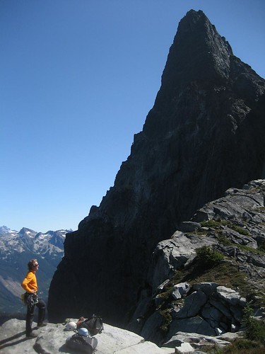
Nick looking back at the NE Buttress.
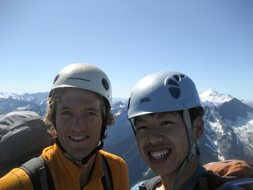
Summit shot